
888.398.4703
++1.760.736.3700
.hm McDonalds Islander Domain Country Information - .hm Heard and McDonald Islands Country Information
.hm

Top Selling McDonalds Islander Domains
Top Domains For Oceania


More Domain
Registration Specials
Price and Requirements for .hm Domains
Registration Pricing
- 1 Year 66.00 USD
- 2 Years 132.00 USD
Application Fee
Registration Time Frame
1 Day
Requirements
Yes Details Are Individual .hm domain registrations allowed?
Yes Details Company or legal entities registrations allowed for .hm?
Yes Details Are there requirements, documents, or information needed for .hm?
Yes Details Are some .hm domain names restricted?
No Details Does .hm domain have a special use?
No Details Other information I need to know about .hm?
No Details Are there any additional fees for .hm?
No Details Do I need a trademark/brand name to register .hm?
No Details WHOIS Privacy service available?
![]() Trustee / Proxy service offered? Fees?
No
Details
Trustee / Proxy service offered? Fees?
No
Details
.hm Heard and McDonald Islands Country Information
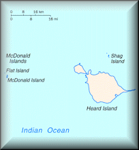
The Heard Island and McDonald Islands (abbreviated as HIMI) are an Australian external territory and volcanic group of barren Antarctic islands, about two-thirds of the way from Madagascar to Antarctica. The group's overall size is 372 square kilometres (144 sq mi) in area and it has 101.9 km (63 mi) of coastline. Discovered in the mid-19th century, they have been territories of Australia since 1947 and contain the only two active volcanoes in Australian territory, one of which, Mawson Peak, is higher than any mountain on the Australian mainland. They lie on the Kerguelen Plateau in the Indian Ocean.
The islands are among the most remote places on Earth: They are located approximately 4,099 km (2,547 mi) southwest of Perth, Western Australia, 3,845 km (2,389 mi) southwest of Cape Leeuwin, Australia, 4,200 km (2,600 mi) southeast of South Africa, 3,830 km (2,380 mi) southeast of Madagascar, 1,630 km (1,010 mi) north of Antarctica, and 450 km (280 mi) southeast of Kerguelen The islands are currently uninhabited.
Heard Island, by far the largest of the group, is a 368-square-kilometre (142 sq mi) bleak and mountainous island located at 53°06′00″S 73°31′00″E. Its mountains are covered in glaciers (the island is 80% covered with ice) and dominated by Mawson Peak, a 2,745-metre (9,006 ft) high complex volcano which forms part of the Big Ben massif. A July 2000 satellite image from the University of Hawaii's Institute of Geophysics and Planetology (HIGP) Thermal Alert Team, University of Hawai'i showed an active 2-kilometre (1.2 mi) long (and 50–90 metres/164–295 feet) wide lava flow trending south-west from the summit of Big Ben.
Mawson Peak is one of only 2 active volcanoes in Australian territory, the other being McDonald Island. It is also one of the highest Australian mountains (higher than Mount Kosciuszko); surpassed only by peaks in the Antarctic territory. A long thin sand and gravel spit named "Elephant Spit" extends from the eastern end of the island. There is a small group of islets and rocks about 10 kilometres (6 mi) north of Heard Island, consisting of Shag Islet, Sail Rock, Morgan Island and Black Rock. They total about 1.1 square kilometres (0.4 sq mi) in area.
The McDonald Islands are located 44 kilometres (27 mi) to the west of Heard Island at 53°02′20″S 72°36′04″E. The islands are small and rocky. In 1980 they consisted of McDonald Island (186 metres (610 ft) high), Flat Island (55 metres (180 ft) high) and Meyer Rock (170 metres (560 ft) high). They totalled approximately 2.5 square kilometres (1.0 sq mi) in area, where McDonald Island was 1.13 square kilometres (0.4 sq mi) large. Like Heard Island, they were surface exposures of the Kerguelen Plateau.
.hm Heard and McDonald Islands Domain Name - Country Information
| Country Domain | Heard and McDonald Islands Domain Name .hm |
|---|---|
| Country Information | Heard and McDonald Islands Domain Country Information .hm |
| TLD Bulk & Advanced Search | Heard and McDonald Islands Bulk Domain Registration .hm |
| WhoIs Server | .hm Whois Server Information |
| Domain Renewals | Renewal McDonalds Islander Domain .hm |
| Domain Transfer | Transfer Domain .hm |
| Domain Hosting | .hm Heard and McDonald Islands Web Hosting |
| SSL Certificates | SSL Certificates |
| Email Services | .hm Heard and McDonald Islands Email Services |
| Domain FAQ | .hm Domain Registration FAQ |
Heard and McDonald Islands Country Information Search Terms
McDonalds Islander Domain Country Information McDonalds Islander Domain Registrar McDonalds Islander World Wide Domain Registration McDonalds Islander Country Code Top Level Domain .hm Domain Information McDonalds Islander Country Information Heard and McDonald Islands Country Information

Socialize
Copyright © RightWay Gate, Inc. / All Rights Reserved / Privacy Policy / Terms & Conditions