
888.398.4703
++1.760.736.3700
.gf French Guianese Domain Country Information - .gf French Guiana Country Information
.gf

Top Selling French Guianese Domains
Top Domains For South America


More Domain
Registration Specials
Price and Requirements for .gf Domains
Registration Pricing
- 1 Year 179.00 USD
- 2 Years 358.00 USD
- 3 Years 537.00 USD
- 4 Years 716.00 USD
- 5 Years 895.00 USD
- 6 Years 1,074.00 USD
- 7 Years 1,253.00 USD
- 8 Years 1,432.00 USD
- 9 Years 1,611.00 USD
- 10 Years 1,790.00 USD
Application Fee
29.95 USD
Registration Time Frame
2 Days
Requirements
Yes Details Are Individual .gf domain registrations allowed?
Yes Details Company or legal entities registrations allowed for .gf?
No Details Are there requirements, documents, or information needed for .gf?
Yes Details Are some .gf domain names restricted?
No Details Does .gf domain have a special use?
No Details Other information I need to know about .gf?
No Details Are there any additional fees for .gf?
No Details Do I need a trademark/brand name to register .gf?
No Details WHOIS Privacy service available?
![]() Trustee / Proxy service offered? Fees?
No
Details
Trustee / Proxy service offered? Fees?
No
Details
.gf French Guiana Country Information
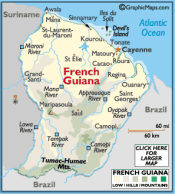
French Guiana is an overseas region of France, consisting of a single overseas department located on the northern Atlantic coast of South America. It has borders with two nations: Brazil to the east and south, and Suriname to the west. Its 83,534 km2 (32,253 sq mi) have a very low population density of less than 3 /km2 (7.8 /sq mi), with almost half of its 229,000 people in 2009 living in the urban area of Cayenne, its capital.
The addition of the adjective "French" in English comes from colonial times when five such colonies existed (The Guianas), namely from west to east: Spanish Guiana (now Guayana Region in Venezuela), British Guiana (now Guyana), Dutch Guiana (now Suriname), French Guiana, and Portuguese Guiana (now Amapá, a state in far northern Brazil). French Guiana and the two larger countries to the north and west, Guyana and Suriname, are still often collectively referred to as the Guianas and comprise one large shield landmass.
A large part of the department's economy derives from the presence of the near-equatorial Guiana Space Centre, the European Space Agency's primary launch site.
Though sharing cultural affinities with the French-speaking territories of the Caribbean, French Guiana is often not considered to be part of that geographic region, because the Caribbean Sea is located several hundred kilometres to the west, beyond the arc of the Lesser Antilles. However, the boundaries of what people have defined as the Caribbean have changed over time. Historically, the boundaries of the Caribbean were at their greatest extent during the 17th and 18th centuries and as such French Guiana was situated on the edge and during some periods may have been thought to be part of the Caribbean proper.
French Guiana lies between latitudes 2° and 6° N, and longitudes 51° and 53° W. It consists of two main geographical regions: a coastal strip where the majority of the people live, and dense, near-inaccessible rainforest which gradually rises to the modest peaks of the Tumac-Humac mountains along the Brazilian frontier. French Guiana's highest peak is Bellevue de l'Inini in Maripasoula (851 m (2,792 ft)). Other mountains include Mont Machalou (782 m (2,566 ft)), Pic Coudreau (711 m (2,333 ft)) and Mont St Marcel (635 m (2,083 ft)), Mont Favard (200 m (660 ft)) and Montagne du Mahury (156 m (512 ft)). Several small islands are found off the coast, the three Îles du Salut Salvation Islands which include Devil's Island and the isolated Îles du Connétable bird sanctuary further along the coast towards Brazil.
.gf French Guiana Domain Name - Country Information
| Country Domain | French Guiana Domain Name .gf |
|---|---|
| Country Information | French Guiana Domain Country Information .gf |
| TLD Bulk & Advanced Search | French Guiana Bulk Domain Registration .gf |
| WhoIs Server | .gf Whois Server Information |
| Domain Renewals | Renewal French Guianese Domain .gf |
| Domain Transfer | Transfer Domain .gf |
| Domain Hosting | .gf French Guiana Web Hosting |
| SSL Certificates | SSL Certificates |
| Email Services | .gf French Guiana Email Services |
| Domain FAQ | .gf Domain Registration FAQ |
French Guiana Country Information Search Terms
French Guianese Domain Country Information French Guianese Domain Registrar French Guianese World Wide Domain Registration French Guianese Country Code Top Level Domain .gf Domain Information French Guianese Country Information French Guiana Country Information

Socialize
Copyright © RightWay Gate, Inc. / All Rights Reserved / Privacy Policy / Terms & Conditions